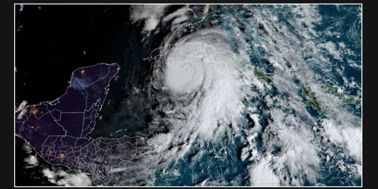
Hurricane Rafael made landfall in Cuba on Wednesday afternoon as a strong Category 3 hurricane. After crossing over the island, it weakened slightly as it moved into the Gulf of Mexico.
The storm, which is currently a Category 2 hurricane, is moving away from western Cuba. Overnight, conditions on the island are expected to improve as the winds, rain, and storm surge diminish.
The hurricane, which resulted in a complete power grid failure on the island, is the fifth significant hurricane to hit the Atlantic this year and the most powerful one at this time of the year since 2020.
Rafael is forecasted to make a westward turn and decrease in speed on Thursday, possibly lingering in the southern Gulf of Mexico throughout the weekend. It is currently unlikely that this storm will affect the northern Gulf of Mexico, but the hurricane center advises those in the southern and southwestern Gulf of Mexico to stay informed about Rafael’s progress. There is still some uncertainty regarding the storm’s final destination, and this will be closely monitored.
As the storm continues to churn over the waters of the southeast Gulf of Mexico on Thursday, meteorologists will be able to provide a more confident forecast.
Rafael unleashed its wrath as the country experienced its first Category 3 hurricane since Ian in 2022.
Before making landfall, officials on state TV announced that thousands of individuals residing in the western Artemisa province had been evacuated from coastal areas. The core of the hurricane, Rafael, made landfall just east of Playa Majana in the province.
Government officials have stated that the island’s national electric system experienced a collapse as Rafael approached, primarily due to the powerful winds.
The Cuban civil defense has issued a state of alarm in the western and central provinces, urging residents to restrict their movement. As a result, the streets of Havana, which are usually bustling, were largely deserted on Wednesday afternoon.
According to the National Hurricane Center, although the center of the storm passed west of Havana, strong winds were still felt in the capital. Wind gusts in Havana reached up to 93 mph, with another gust at the international airport measuring 71 mph.
According to data from the NOAA, Rafael holds the distinction of being the most powerful hurricane to traverse the northwestern Caribbean in November since 2009.
Rafael’s potential track through the Gulf of Mexico later this week and over the weekend is gradually becoming clearer, although there is still a lot of uncertainty.
Rafael remains a potential threat to the US as the sixth named storm of the season. However, experts are beginning to narrow down the areas that may be affected.
According to the center, Rafael is forecasted to move away from western Cuba this evening and continue its path over the southeastern Gulf of Mexico. It is expected to remain in the southern Gulf of Mexico for the next few days.
Rafael’s impact in the US may be limited, but the abundant tropical moisture that is currently driving the storm could lead to heavy rainfall in the Southeast.
According to forecasters, the lower and middle Florida Keys may experience rainfall ranging from 1 to 3 inches.
The Southeast may experience bursts of rain that could lead to hazardous flash flooding. However, due to the dryness of the soils following a record-breaking October, some areas may be slower to flood.
Contributors to this report include Robert Shackelford, Taylor Ward, Brandon Miller, Steve Almasy, José Álvarez, Patrick Oppmann, Michael Rios, Dave Alsup, and Hanna Park from CNN.

