On Sunday afternoon and evening, severe thunderstorms are expected to pass through seven states, posing a threat of very large hail in Nebraska and causing damaging winds across the Plains.
A severe weather threat looms over a significant portion of the central United States, stretching from Texas to Minnesota. Thunderstorms are expected to roll in, potentially bringing with them tennis ball-sized hail. Residents in Nebraska are particularly at risk, as a large area in the state could be affected by this severe weather phenomenon.
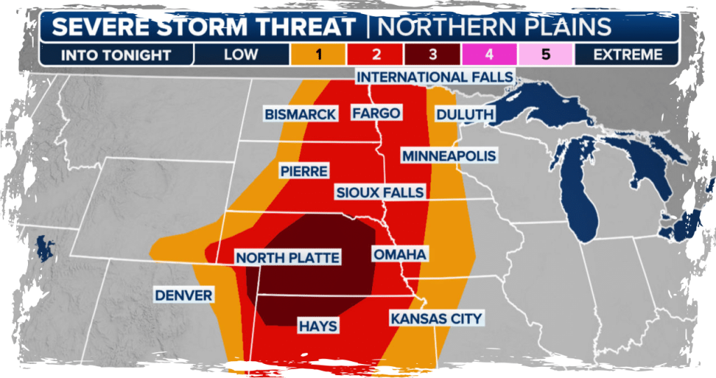
The Storm Prediction Center of NOAA has issued a Level 3 out of 5 risk for severe thunderstorms during Sunday afternoon and into the night across Nebraska and north Kansas. In this region, there is a possibility of experiencing severe weather conditions such as very large hail up to 3 inches in diameter, damaging winds ranging from 60 to 80 mph, and the potential occurrence of a tornado or two.
Sunday afternoon will see the onset of thunderstorms in eastern Nebraska and central Kansas.
According to FOX Weather Meteorologist Jane Minar, discrete supercells are projected to form along the cold front and dry line boundary in the late afternoon and evening. These storms in Nebraska pose a greater risk of generating tornadoes.
The risk area encompasses several locations, including Grand Island, Kearney, North Platte, Norfolk, Nebraska, and areas northwest of Kansas City, Kansas.
On Sunday, the Storm Prediction Center (SPC) issued a Level 2 out of 5 risk for severe thunderstorms, expanding the area of concern to include the Plains and Southwest. This increased risk zone encompasses a population of 9.5 million people and includes major cities like Wichita, Kansas, and Lincoln, Nebraska. Additionally, it spans across a wide range of locations from southwest Texas all the way up to Minnesota.
Severe thunderstorms have started to sweep across North Texas and southern Oklahoma during Sunday afternoon, bringing with them the possibility of large hail, measuring up to 2 inches, as well as strong wind gusts reaching speeds of up to 70 mph.
The National Weather Service in Norman, Oklahoma has issued a Tornado Watch for areas in the Oklahoma Panhandle and West and Northwest Texas. This watch will remain in effect until Sunday night.
Conditions that are favorable for tornadoes to form are indicated by a Tornado Watch.
Widespread rain and gusting winds are set to impact areas like Des Moines, Iowa, and Minneapolis, Minnesota on Sunday. However, the strongest line of storms is predicted to arrive in Nebraska after dark on Sunday night.
Heavy rain is expected between Sunday night and Monday morning, which could potentially result in flash flooding in the northern Plains. The risk of flooding will continue into Tuesday for areas in Nebraska that are located along the Missouri River.
According to the FOX Forecast Center, the main risks during the overnight hours are wind and rain.