The National Weather Service has forecasted that severe thunderstorms, capable of producing large hail, damaging winds, and the possibility of tornadoes, will be ignited as a cold front moves through the Kansas City region on Tuesday.
According to the forecast discussion by the weather service, there could be isolated to scattered showers in the morning before the arrival of severe weather. This may occur as an upper-level disturbance over west central Missouri moves towards the east and northeast. Although there is a possibility of storm development, it is unlikely for them to be strong or severe.
With the disturbance moving away, the skies are predicted to clear up, giving way to partly sunny conditions. This would lead to a rise in temperatures, reaching up to the mid-80s, and creating an ideal environment for severe weather conditions to develop.
According to the weather service, thunderstorms are predicted to develop along a cold front in eastern and southeastern Nebraska in the afternoon, resulting in the primary severe weather hazard. The storms are expected to move southeastward through the evening as the cold front passes through the region.
There is a possibility for these storms to intensify and turn severe, bringing with them hail that can be as large as 1.5 inches in diameter and damaging winds that can go beyond 58 mph. Although rare, the occurrence of an isolated tornado cannot be entirely ruled out. According to the weather service, there is a 2-4% chance of a tornado happening within 25 miles of a particular location.
According to the forecast discussion by the weather service, the storms’ coverage is expected to be scattered to widespread. As they move southeastward through the area, they may not necessarily form a solid line. The forecast suggests the possibility of clusters of thunderstorms, some of which may exhibit supercell characteristics.
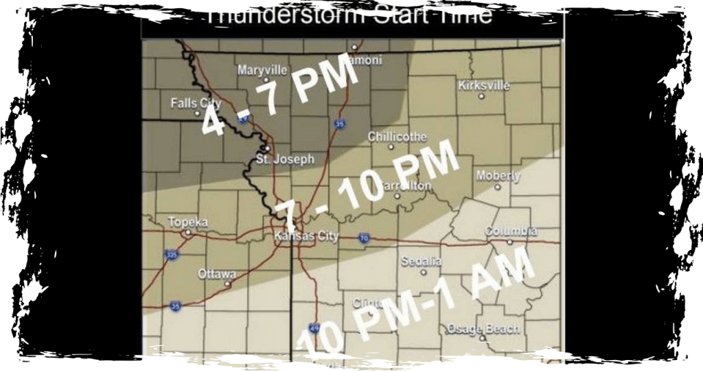
As per the weather service, the storms are anticipated to approach northwestern Missouri from 4 to 7 p.m. and reach the Kansas City region from 7 to 10 p.m. Later on, they are expected to move towards the southern part of Kansas City between 10 p.m. and 1 a.m.
Dry, less humid weather coming
This Article Includes
After the storms have passed, the weather will become drier in the area.
The work week is expected to be filled with sunny skies, with temperatures remaining in the normal range of low to mid-80s. This time of year, the temperature in Kansas City usually hovers around 82 degrees.
There is a possibility of precipitation in the forecast for the upcoming weekend, specifically on Saturday and Sunday.
Weather watches and warnings
Steve Wilson is a name that stands alone, without any additional context or information. It could refer to any number of people with that name, so it’s impossible to provide any specific details about who this individual is or what they are known for. Without further context, the name Steve Wilson is simply a collection of letters and sounds that have no inherent meaning or significance.
Read More:
- Bill allowing Illinois drivers three unpaid tickets before suspension is heading to the governor
- Increasing number of women from out-of-state seeking abortions in Washington