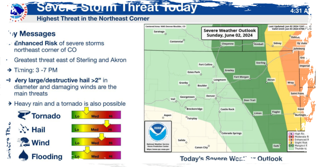
Severe weather is anticipated to develop in northeastern Colorado on Sunday, bringing with it the potential for large and destructive hail. The late afternoon and evening hours are expected to be particularly vulnerable to this hazardous weather phenomenon.
The northeastern corner of the state is currently facing an increased risk of severe storms, which could result in the formation of destructive hail. These hailstones are expected to be larger than 2 inches, even surpassing the size of golf balls.
According to the National Weather Service (NWS) in Boulder, the likelihood of severe weather increases as you move further east from Sterling towards the borders of Kansas and Nebraska.
The National Weather Service (NWS) has warned that storms developing over far northeast Colorado could bring about damaging winds, very heavy rain, and the possibility of an isolated tornado.
Sunday’s weather in Denver is expected to bring mostly isolated showers, although the day will begin with abundant sunshine.
According to Denver7 weather forecaster Katie LaSalle, the weather in Denver is expected to become increasingly cloudy later today, accompanied by gusty winds. By noon, it will be breezy with temperatures reaching 83 degrees. As the afternoon progresses, the skies will become mostly cloudy. However, the risk of severe weather in Denver and the western regions is expected to be low. Although a few showers and isolated storms may occur in the mountains and across northwestern Colorado.
Late-day showers or storms could be possible in the Denver metro, Boulder, and Fort Collins areas. However, the severity of the weather threat increases as you travel eastwards.
Greeley, Fort Morgan, Limon, Sterling, and Akron communities are currently at a marginal risk for severe weather.
Wray, Julesburg, Holyoke, and the surrounding communities along I-76 face an increased risk of experiencing strong to severe storms accompanied by large, destructive hail.
According to the NWS, Sunday’s storms may bring not only high winds and larger hail but also the potential for flooding and an isolated tornado.
The storms are projected to occur between 3 p.m. and 7 p.m. on Sunday. At this time, no weather watches have been issued as of early Sunday morning.
The weather in Denver is expected to heat up this week, with temperatures reaching 90 degrees on Monday and rising to 92 degrees by Wednesday. There is also a possibility of afternoon storms throughout the week.