Millions of Americans hoping to travel early for the Christmas holiday are facing potential disruptions due to winter storms.
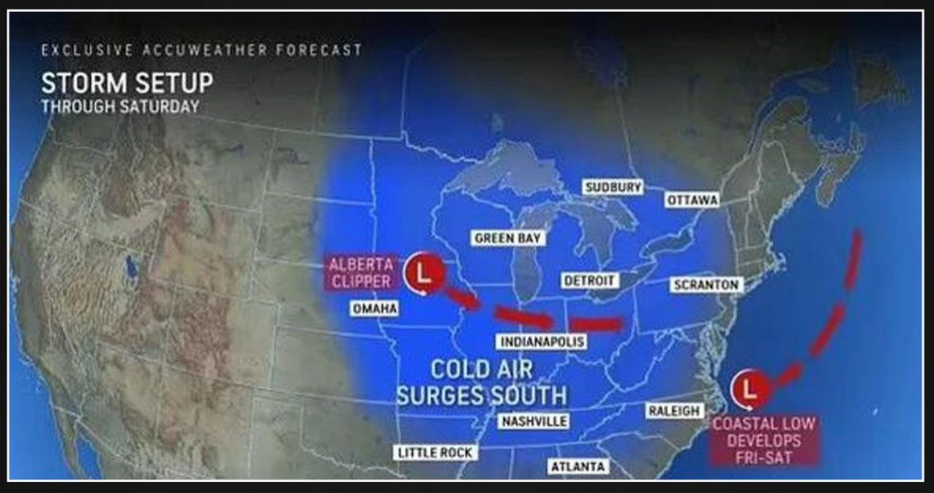
Two systems are set to bring heavy snow and high winds to airports and roadways in the Midwest and Northeast until Saturday.
An ‘Alberta clipper’ storm, named after its origin in central Canada, is currently moving southeastward across the Upper Midwest. This system has already brought a few inches of snow to certain areas of the region.
The National Weather Service (NWS) issued a warning that the ongoing storm in the Midwest is anticipated to generate a minimum of four inches of snow, resulting in the formation of hazardous road conditions.
The states that will be affected by this storm are North Dakota, Wisconsin, Illinois, Michigan, Indiana, Ohio, West Virginia, Virginia, and Maryland.
The northeastern region, comprising Pennsylvania, New Jersey, central and southern New York, and southwestern New England, may also experience potential impacts.
A new storm is currently forming in the Atlantic near the Carolinas, which poses a potential threat of heavy snowfall and strong winds for the Northeastern region.
Connecticut, Massachusetts, New Hampshire, southwestern Maine, and parts of Long Island, New York are the states that will bear the brunt of the snowfall from this storm. Rhode Island and down East Maine will also be affected.
According to Bernie Rayno, the Chief On-Air Meteorologist at AccuWeather, the snow can pose a significant risk as it has the potential to quickly intensify and fall heavily during the afternoon and evening rush hour on Friday in the Northeast.
AccuWeather warns that when snow accumulates quickly and road surfaces cool down, it can create hazardous conditions on the roads. This can lead to slower traffic and an increased risk of accidents.
Cities in the northeastern region that are at risk for these conditions include New York City, Baltimore, Philadelphia, Allentown, Scranton, and Harrisburg in Pennsylvania.
According to Rayno, the conditions in and around New York City can be quite tricky.
The area may receive a coating of one to two inches of snow from the clipper storm, and potentially more if the coastal storm shifts westward. However, there is also a possibility of being in a rip-off zone where only a few flurries or no snowfall occur.
Before the peak storm impacts hit the Northeast, the Alberta Clipper will bring heavy snowfall to the Midwest. In certain areas, the snow has already started falling.
By midday on Thursday, a few inches of snow had fallen in Fargo, North Dakota, Minneapolis, and Madison, Wisconsin.
Chicago, Milwaukee, and Detroit should brace themselves for a significant amount of snowfall starting Thursday evening and continuing through Friday morning.
According to AccuWeather, there is a high probability of significant travel disruptions on both roads and at airports. The snowfall is expected to cause delays along the Interstate 80/90 corridor, leading to slower travel times.
Snowfall of one to two inches is expected in Indianapolis, Pittsburgh, and Columbus, Ohio on Friday.
By Friday evening, the Alberta clipper will arrive at the central Appalachians, bringing with it up to two inches of snowfall across various regions. These include West Virginia, northern Maryland, northern Virginia, Pennsylvania, New Jersey, central and southern New York, and southwestern New England.
However, there are areas within this region that should anticipate experiencing pockets of moderate to heavy snowfall, resulting in the accumulation of several inches of snow.
By now, the storm forming off the Atlantic coast is expected to bring heavy snow and strong winds to the Northeast from Friday night to Saturday morning.
Providence, Rhode Island, Boston, Hartford, Connecticut, Portsmouth, New Hampshire, and Portland, Maine may experience rainfall amounts of two to three inches if the storm intensifies rapidly, reaches its projected peak strength, and stays near the coastline.
If you’re planning to go on a road trip this weekend, the NWS recommends checking road conditions in advance by calling 511 or visiting 511ia.org. It is also advisable to drive during the daytime, stick to main roads, and exercise extra caution.
To ensure your safety on the road, it is important to maintain a sufficient distance between your vehicle and the one in front of you. This can be achieved by leaving ample space and adhering to a safe speed.
While these wintry conditions may cause travel disruptions across much of the US, there is a silver lining.
According to AccuWeather, there is a high possibility that any snowfall occurring on Saturday may remain until Christmas morning in certain areas of the region.
Also Read: Minor 3.7 Magnitude Earthquake Recorded in the United States
