
According to an article by NIKK OGASA published in Science News, recent research has revealed significant findings in the field of science.
New data has revealed that the most devastating Cascadian earthquakes are more likely to occur off the shore of Washington state and Vancouver Island, rather than the Oregon coast.
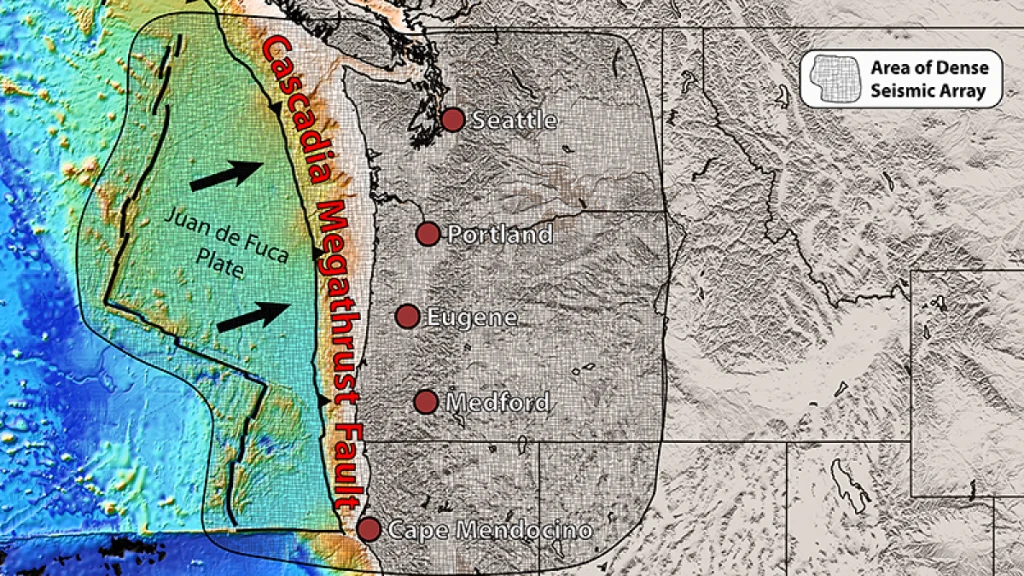
Scientists have been trying to understand the structure of the Cascadia megathrust, a massive fault that is believed to have the potential to cause catastrophic magnitude 9 earthquakes similar to the 2011 Tohoku earthquake. However, despite their efforts, the structure of this fault has remained a mystery for a long time.
According to the latest survey, it has been found that the fault is not a single, uninterrupted fracture but is actually made up of a minimum of four segments. The most perilous segment seems to extend from the shores of southern Vancouver Island to Washington state, as per the findings published in the June 7 edition of “Science Advances”.
Seismologist Edwin Nissen from the University of Victoria in British Columbia, who was not part of the study, emphasizes that the Cascadia megathrust poses a significant threat to those residing in the Pacific Northwest.
According to the expert, the fault that runs along the southwest coastline of Vancouver Island may be the primary area for the most significant earthquakes. However, he suggests that sections further south along the coast of Oregon could be prone to more frequent and slightly smaller tremors.
The fault has been divided into four segments, which has led scientists to ponder whether it will collapse as a whole or if individual segments will rupture.
According to The Washington Post, Harold Tobin, a seismologist at the University of Washington and one of the paper’s authors, stated that the answer to the complicated question is not straightforward. He commented, “That’s the messy question, where the answer is more like: sometimes it does one thing, and sometimes another.”
Experiencing either of these situations would be considered a significant natural disaster, potentially distinguishing between a single magnitude-9 earthquake and two magnitude-8 earthquakes. Tobin referenced the occurrence of two enormous earthquakes in Japan in 1944 and 1946, where two distinct sections of a fault ruptured in quick succession, leading to both causing lethal tsunamis.
When two tectonic plates converge, especially in subduction zones, megathrust faults can occur. These types of faults happen when one plate pushes under the other, causing the plates to become stuck and periodically slip. This movement releases massive amounts of energy, resulting in powerful earthquakes. Some of the most significant earthquakes in history, such as the 2004 Sumatra quake, have occurred in these settings.
The shoreline of North America’s west coast is home to the Cascadia megathrust, which stretches from British Columbia to northern California. This is where the North American plate is slid under the northeast-bound Juan de Fuca plate.
Over the course of the last 10,000 years, Cascadia has experienced 19 earthquakes that were greater than magnitude 9. The most recent one, which took place in 1700, had a magnitude of 9 and resulted in coastal forests falling into the tidal zone, causing tsunami waves that even reached Japan. The looming danger of the next Cascadian earthquake has sparked a plethora of articles, books, and documentaries.
The Cascadia fault, despite being a significant fault line, is not as well-researched as the megathrusts located offshore Japan and New Zealand.
Nissen explains that subduction zones usually experience frequent small earthquakes, providing valuable insights into fault structures. However, Cascadia stands out as an exception due to its unusual lack of seismic activity.
Columbia University’s marine geophysicist, Suzanne Carbotte, and her team conducted a seismic survey in 2021 using the Marcus G. Langseth research vessel. The survey covered a 900-kilometer area of the zone and involved towing underwater air guns to create sound waves that were blasted into the seafloor. As these waves hit faults and rock layers beneath the seafloor, they were reflected back up and detected by a 15-kilometer-long array of receivers pulled behind the vessel.
According to Carbotte, this is the initial instance where a comprehensive study covering almost the entire subduction zone has been carried out at a regional level. Previously, researchers focused on limited areas, typically around 200 kilometers at most.
According to the findings, the Juan de Fuca plate undergoes a splitting process into segments when it grinds beneath the North American plate. This process takes place similar to a sheet of plywood passing through a row of buzzsaws. The primary cause of this segmentation is the uneven distribution of rigid rocks in the North American plate, which results in uneven warping of the incoming plate.
Nissen emphasizes the significance of segmentation in preventing earthquakes. “That’s one way to stop an earthquake,” he explains.
When an earthquake occurs, it all begins with a single underground point called hypocenter, where the fault starts to slip. The movement then extends along the fault. The size of the fault plays a significant role in the propagation of temblors, resulting in more prominent and longer-lasting quakes.
When a fault is segmented, the fractures can hinder the movement from one segment to another. This can restrict the magnitude of the earthquake and prevent it from getting too large.
According to Nissen, earthquakes can still propagate through multiple segments or even all of them.
According to Nissen, there is proof that the earthquake in 1700 was indeed severe.
According to Nissen, the data indicates that the segment originating from southern Vancouver Island is comparatively even, which makes it more conducive for earthquakes to develop. Additionally, it seems to descend beneath the North American plate at a minimal angle of around 2 to 4 degrees. Typically, the most significant earthquakes happen on faults that dip shallowly within subduction zones.
Nissen explains that in cases where the earthquake is shallow and has a gentle dip, there is a possibility for it to spread further towards the east and eventually reach the coastline, affecting those residing in Victoria, Seattle, and Vancouver. This means that the impact of the earthquake could be more extensive than previously anticipated.
“This research offers valuable insights into the assessment and prediction of earthquakes,” Mark Petersen, a geophysicist from the U.S. Geological Survey in Golden, Colo. and head of the National Seismic Hazard Model Project, comments on the study. He was not involved in the research, but acknowledges that it provides a wealth of information on the subject.
Understanding the specifics of the fault’s geometry is essential in determining the proximity of potential future earthquakes to highly populated cities like Seattle. According to the expert, the agency’s hazard model for the Pacific Northwest will be updated in 2029.
According to the survey results, there are some minor faults located near the coast that have the potential to slip and cause tsunami waves. Although it would take a few minutes for waves generated by a megathrust earthquake further offshore to reach the coast, if these faults near the shore were to slip, the resulting tsunami could hit the beach much sooner. This information was provided by Nissen.