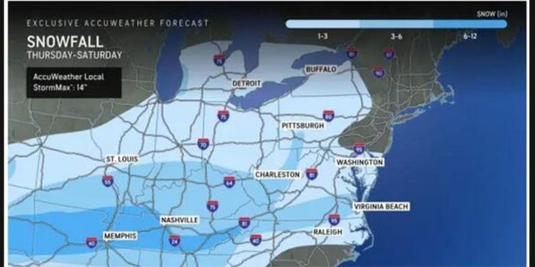
The latest snowfall projections are now available for a powerful winter storm making its way from the southern states to the Northeast. This storm is expected to bring dangerous travel conditions.
The storm will bring about slippery travel conditions throughout the region, although the heaviest snowfall is anticipated south of Washington, DC.
“While a general 1 to perhaps 3 inches of snow is forecast, there can be pockets where a coating or a dusting of snow could be all that falls from the storm, especially along the upper mid-Atlantic coast,” AccuWeather Senior Meteorologist Brett Anderson said.”
Final Snow Accumulation Projections
Take a look at the image above.
-
- Light Blue Areas: 1 to 3 inches
- Next Shade: Up to 6 inches
- Dark Blue Areas: Up to a foot
“Even with a light amount of snow, slow and slippery travel on the roads is anticipated, along with a significant number of airline delays due to de-icing operations,” according to AccuWeather. “As aircraft and crews are displaced by the southern storm, the number of flight cancellations may climb even before the storm arrives in the Northeast.”
Timing By Region
The timing of events can vary based on the region.
-
- Maryland-Virginia: Precipitation begins around 11 p.m. Friday, Jan. 10.
- Pennsylvania, New Jersey, New York, Connecticut, Rhode Island, and Massachusetts: Snow and sleet expected to start between 4 a.m. and 7 a.m. Saturday, Jan. 11.
After daybreak on Saturday, we can expect a combination of precipitation, accompanied by mostly cloudy skies that will persist throughout the day.
Flurries may continue into the evening in some areas, but by Saturday afternoon, the system will gradually wind down.
On Sunday, January 12, we can expect clear skies and temperatures ranging from the mid to upper 30s.
